The North Rukuru River is to Chitipa and Karonga districts at the northern tip of Malawi what the Nile River is to Egypt: A source of life. So is the South Rukuru in Rumphi.
The river irrigates maize, rice and banana fields, and replenishes rivers and Lake Malawi where families fish for improved livelihoods and commerce.
The river peacefully flows down the mountains of Chitipa, splitting thick forests and fertile farmlands on the way to Lake Malawi.
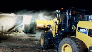
However, since the 1970s, the highly silted river has become shallow with bare banks.
Chronically, it presents some unwelcome surprises to the people of Karonga along the lake: destructive floods that devastate property and claim lives.
For the past five years, both the frequency and the intensity of these occurrences have escalated.
Every time it rains, the shallow river breaks its banks, ruining houses, schools, crops and livestock.
This exacerbates hunger and poverty in vulnerable communities.
This year was no exception.
The floods devastated Linda Nyirenda’s ricefield, leaving her family of five with virtually no food until the next farming season.
Her kitchen was also ravaged by the floods.
After the misfortune, Nyirenda was seen replanting the rice, hoping to sell part of the harvest and rebuild her kitchen.
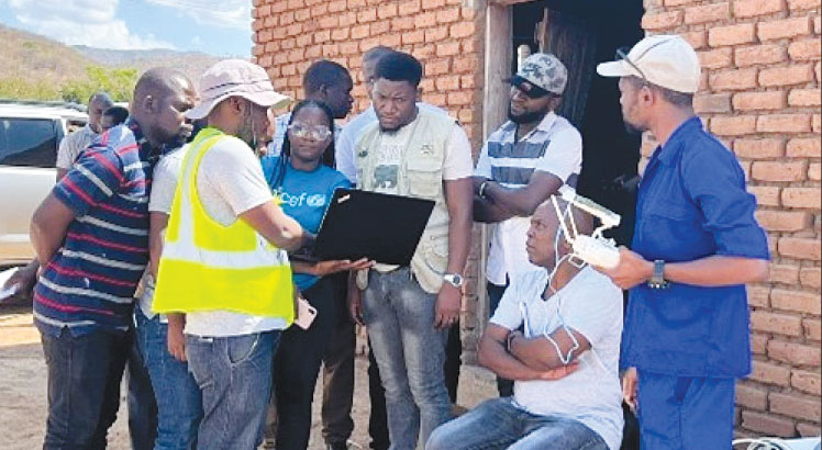
Drones for good
To lessen the impact of these floods on vulnerable families such as hers, Unicef Malawi, with backing from UK-based ARM and Unicef Office of Innovation, rolled out the use of drones along the South and North Rukuru rivers.
This project assesses the impact of flood forecasting and early warning systems using high-resolution aerial imagery for flood modeling.
The drones helped establish the basis for flood forecasting in disaster risk reduction.
The drones linked to Globhe, a global health platform, collected aerial photos and generated digital terrain models for flood-prone areas.
Utilising this data, the team developed a high-resolution flood model for accurately predicting the timing, location and magnitude of floods.
The drone also mapped out potential flood paths.
The Globhe’s platform connects drone operators with clients in need of data from the sky.
It is the largest drone data marketplace in the world, covering 134 countries.
Says Unicef Malawi Innovation Specialist Tautvydas Juskauskas: “This level of detailed forecasting and predictability will empower at-risk communities to make informed decisions, strategically planning to minimise loss of life and property during floods.
“Furthermore, it will guide decisions regarding the optimal locations for infrastructure development, such as schools, hospitals, homes, and farms.”
The team deployed to capture aerial data was led by Alexander Mtambo, a former student of the African Drone and Data Academy at Malawi university of Science and Technology supported by Unicef.
He now heads Drones Africa at Globhe.
He states: “We’ve gathered data from 6 200 hectares of land along the Rukuru River in Rumphi and another 13 500 hectares in Karonga.
“Drone data capture is highly effective, offering both accuracy and high resolution. It provides us with an almost true-to-life representation of the terrain features on the ground, enabling us to create a flood risk model map that will accurately guide flood preparedness and disaster response activities.”
The academy has trained more than 1000 drone pilots spread across the country and the rest of Africa who respond to such assignments at short notice and in a cost-effective manner.
More detailed
Juskauskas explains: “The data they have collected incorporates ground control points, linking them to known coordinates on the ground. This provides precise vertical and horizontal positioning on the earth’s surface.
“The resolution greatly surpasses that of satellites, which typically offer a 5–30-metre resolution, compared to the five-centimetre resolution for the orthomosaic maps and 50 centimetres for digital surface and digital terrain models,”
Fidelis Mandalazi, a Systems Analyst at the Department of Disaster Management Affairs, says the two districts currently lack a functional flood model or an early warning system.
“The incorporation of drones in flood modelling will significantly enhance disaster management capabilities and the prospect of safeguarding communities from the destructive impact of floods, such as those witnessed in Malawi this year,” he says.
Yobu Kachiwanda, head of public weather services at the Department of Climate Change and Meteorological Service, underscores that this data will only be beneficial if transformed into actionable insights that contribute to building more climate-resilient communities.
But Mtambo says the team’s participation in the project showcases the advanced technical skills youthful Malawians now possess and how the know-how can improve the lives of children and their families.
He elaborates: “Floods can displace families, forcing some to live in camps with inadequate water and sanitation facilities, thereby exposing them to diseases like cholera.
“Our involvement in this project can enhance the lives of children by providing their families and the government with information that can prevent them from finding themselves in such situations in the first place.”