Oil search: Hamra completes aerial survey, eyes seismic
Hamra Oil Holdings Limited (HOHL) has completed the first phase of oil exploration using a full tensor gravity gradiometry (FTG) survey—the first firm to do so in Malawi.
According to Ben Chiza Mkandawire, a senior Hamra official based in Lilongwe, the company is still analysing the FTG data ahead of a possible seismic survey.
Asked whether the data analysed so far has some ‘green shoots’ of hydrocarbon trappings in sediments as widely believed, Mkandawire said it is too early to tell.
“We are at the earliest stages of preliminary oil exploration processes. It will take a bit of time to state with any degree of certainty whether Malawi has oil or not and, if it is there, can it be extracted economically?” he said in a follow-up interview on Saturday.
Mkandawire, however, said once full results of exploration are out, he was sure the Malawi Government—as the custodian of natural resources in the country—would make appropriate announcements.
Secretary for Natural Resources, Energy and Mining Ben Botolo yesterday said government is yet to discuss the FTG results with the company.
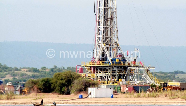
Hamra—which controls oil exploration blocks Two and Three covering Karonga, Rumphi, Nkhata Bay and Nkhotakota with British firm Surestream Petroleum as a minority partner—carried out the FTG in the last quarter of 2014.
Mkandawire said the FTG survey is conducted in passive mode—that is, it records the natural gravity and magnetic field and accurately measures small changes in the gravity field caused by sub-surface densities at prospect level resolution.
The system, he said, works by taking ultra-sensitive real-time measurements of the differences in the gravity gradient field in all directions.
In carrying out the exercise, Hamra was using an airplane that flew over the two blocks.
The company hired Bell GeoSpace—a world leader in FTGs—to carry out the study.
Bell GeoSpace used a BT67 aircraft, which is a converted DC-3 fitted with twin turboprop engines and state-of-the-art digital avionics.
The survey acquired 16 056 line kms over Lake Malawi. The airplane flew in north-south orientation with one (1) km spacing for optimum coverage and the flying altitude was 80 metres above the surface of Lake Malawi with a cruise speed of 90-110 knots.
Among other things, it collected images of sedimentary basin as well as internal architecture to identify structural leads that may become a focus for seismic acquisition.
Mkandawire added that data analysis will take about three months and would determine planning for a 2D seismic programme, subject to government approval.
A seismic survey is one form of geophysical study generally used by oil and gas explorers to produce detailed images of the various rock types and their location beneath the earth’s surface and they use this information to determine the location and size of oil and gas reservoirs, according to expert information from online sources.
Mkandawire thanked people of Karonga, Rumphi, Nkhata Bay and Nkhotakota as well as all Malawians for their patience and support during the FTG.
In the fourth quarter of last year, Hamra sent 10 Malawians to study oil and gas engineering in the United Arab Emirates (UAE) on scholarships so that—should Malawi discover the hydrocarbons—the country must have its own experts to participate in the industry.