If you visit most of the resort units along Lake Malawi today you will likely not have a feel of the sandy beaches because they are submerged due to swelling water levels.
The situation has stirred panic among tourism investors, local populations, visitors and other stakeholders.
National Water Resource Authority (NWRA) has since attributed the rising lake level to successive seasons of intense rainfall.
The Nation spot-checks in lakeshore districts of Mangochi, Salima, Nkhata Bay and Karonga as well as Shire Valley districts of Chikwawa and Nsanje and on Likoma Island have established worsening flooding as lake water steadily spills beyond its shoreline into surrounding communities.
In Mangochi, parts of several lakeside resorts are submerged while some lodges and cottages have become inaccessible as water has engulfed buildings and surrounding premises, forcing residents and visitors to wade through flooded areas.
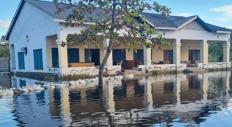
almost in water.
| Jonathan Pasungwi
In some cases, tourism facilities along the lakeshore are heavily affected, with some structures rendered inhabitable after water flooded some rooms, pathways and recreational areas.
Surrounding communities are not spared either as the flood waters have forced families to abandon their homes and seek refuge in safer areas.
In an interview, Mangochi Municipality Council director of planning and development Fortune Msukwa said the disaster has severely affected the district, particularly low-lying residential areas.
“Besides cottages and lodges, the other most affected parts here are Ngalamu and Mapila residential areas where almost entire communities have relocated to upland areas. Currently, we have one evacuation camp at Wisdom of Hope Private School which is sheltering about 30 households,” he said.
Besides damaging tourism infrastructure, the floods have disrupted livelihoods for communities that depend on farming and fishing along the lakeshore.
In Karonga, district commissioner (DC) Willard Mwambo said the continued rise in lake levels has affected businesses, agriculture and critical infrastructure.
“Some homes, roads, schools and trading centres near the lake have either been damaged or are at risk due to continuous shoreline erosion. Communities living along the lake are experiencing displacement, while access to clean water and sanitation has become more difficult in some affected areas,” he said.
Likoma DC Abubakar Nkhoma, in a separate interview, also confirmed that the district is not spared the lake overflow, but could not give details, saying they are still assessing the extent of the damage.
However, group village head Chalunda on the island said at least 50 households in her area, namely Chiwoko, Jalo and Mbamba villages have already been displaced by the flooding.
Chikwawa district disaster risk management officer Charity Machika said high water levels linked to Lake Malawi rising levels have flooded farmland along the Shire River, the lake’s sole outlet, particularly in the East Bank where many farming communities have seen their fields submerged.
In a written response yesterday, NWRA spokesperson Masozi Kasambala attributed the continued rise in Lake Malawi’s water levels to a catchment-wide “hydrological response” caused by successive seasons of above-normal rainfall.
He said Lake Malawi receives water from a vast catchment through rivers and direct rainfall, and because of its large storage capacity, water levels do not immediately recede after one rainy season ends.
“When rainfall is above normal for more than one season, the lake does not immediately return to its previous level because it has a very large storage capacity. Therefore, high inflows in one year becomes a high starting level for the next year,” said Kasambala.
He warned that flooding remains a major risk because Lake Malawi is already at a critically high level such that even a small additional rise can inundate large areas along flat shorelines.
Kasambala further said although increased discharge through the Kamuzu Barrage in Liwonde, Machinga is helping to ease pressure on the lake, the authority cannot increase water releases indefinitely because that would significantly increase flood risk in the Lower Shire.
“The barrage is operating at one of its highest release levels in recent years to reduce pressure on the lake. However, releases cannot be increased indefinitely because the Shire River system has a limited carrying capacity,” he said.
According to NWRA, the 2025/26 peak level was about 476.45 metres above the sea level (masl) and that as at May 7 2026, the lake water level stood at about 476.41 masl.
Historically, Lake Malawi reached its highest recorded level of 477.22 masl in 1980.
But the lake has since experienced natural fluctuations, with lower levels recorded during the dry cycle between 2012 and 2017 when levels remained around 473–474 masl.
In the past five years, there has been a consistent upward trend in lake levels, averaging 474.8-475.0 masl in 2020/21 and 2021/22 to above 475.9 masl in 2023/24.
During the 2024/25 season, levels exceeded 476.3 masl and in the current 2025/26 season, the lake has remained unusually high, reaching approximately 476.45 masl in mid-April 2026.
The swelling levels in the 2024/25 season left hospitality establishments, homes and farm lands submerged.